TAKING THE HISTORIC ROAD TO THE DUNSTAN
Track grade, 3
Central Otago’s dry summer weather and often rocky ground makes for ideal Adventure riding. The region is also blessed, with several dry weather through roads that can be combined to form multi-day adventures. Many of these trails were associated with the pioneering days of the great Otago gold rush of the mid eighteen hundreds. The Hawksburn Track was one of these. Once the prospectors, miners and the rag-tag followers of the rush reached Clyde (then called Dunstan) via the Dunstan Trail, the Hawkesburn was the route on to Bannockburn, and the Wakatipu goldfields. Unlike the modern road, which lies on the river’s north banks, this virtual extension of the Dunstan Trail tenaciously followed the south banks of the Clutha and Kawerau Rivers. Only the section from Clyde to Bannockburn can now be followed, though traces of the road can still be seen on the oppostire side of the Kawerau Gorge from Highway 6. What a ride it would have made!
Central Otago’s dry summer weather and often rocky ground makes for ideal Adventure riding. The region is also blessed, with several dry weather through roads that can be combined to form multi-day adventures. Many of these trails were associated with the pioneering days of the great Otago gold rush of the mid eighteen hundreds. The Hawksburn Track was one of these. Once the prospectors, miners and the rag-tag followers of the rush reached Clyde (then called Dunstan) via the Dunstan Trail, the Hawkesburn was the route on to Bannockburn, and the Wakatipu goldfields. Unlike the modern road, which lies on the river’s north banks, this virtual extension of the Dunstan Trail tenaciously followed the south banks of the Clutha and Kawerau Rivers. Only the section from Clyde to Bannockburn can now be followed, though traces of the road can still be seen on the oppostire side of the Kawerau Gorge from Highway 6. What a ride it would have made!
Only the section from Clyde to Bannockburn can now be followed.
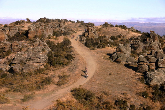
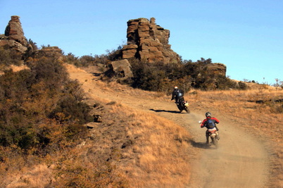
Central Otago is blessed with many dry weather summer roads. The Hawkesburn Road was a pioneer gold miners route to the diggings beyond Clyde.
I have mapped the Hawksburn Road west to east from Bannockburn to Clyde, making the only steep section of the road the final descent, though it can be done either way. Sandwiched in lower ground between the dry Cairnmuir Range and the higher Old Man and Old Woman Ranges, the road generally follows good grades and is well graveled, On the final eastern section the surface becomes rougher and the grades are quite steep, though traction is still good. The middle sections have a remote feeling, until the top of that last descent, when there are excellent views of the Clyde Dam, Dunstan Mountains and the Manuherakia Valley.
The Hawksburn Road is an excellent beginners ride, but well worthwhile for experienced adventurers alike and also serves as an alternative extension to the more challenging Nevis Road.
The Hawksburn Road is an excellent beginners ride, but well worthwhile for experienced adventurers alike and also serves as an alternative extension to the more challenging Nevis Road.
FOLLOWING THE ROUTE INSTRUCTIONS
• Distances are in kilometers
• TL Turn left
• TR Turn right
• SO Straight on
Please note that road signs often change or are vandalized, so please remember this is an adventure. Odometer accuracy, tyre size and riding styles cause distance readings to vary.
• TL Turn left
• TR Turn right
• SO Straight on
Please note that road signs often change or are vandalized, so please remember this is an adventure. Odometer accuracy, tyre size and riding styles cause distance readings to vary.
HAWKSBURN ROAD
Start Cromwell
Finish: Clyde
Total distance: 34 km (distance approx.)
Route grade: 3. (Formed surfaced gravel road, surface uneven in parts, surfaced fords and or bridges.) This is an easy ride easy in fine summer weather, though there are a couple of steep-ish decents near Clyde and some rough sections.
Dangers: Beware the occasional rutted section and exposed rock surface. The road is more frequently used than might appear, watch for oncoming vehicles. Not recommended in frosty weather.
Download the route instructions below.
| hawksburn_route_instructions.pdf |